Lothagam was too expansive, too important, and just too beautiful to be limited to a one-day visit or one blog post.

There are more fossils to find and more canyons to explore.
As usual, the students rose with the dawn, the red rocks of Lothagam radiant with scarlet light. Quickly the nets and bedrolls were packed away, boots were laced, sunscreen applied, and we were off down the riverbed on a second excursion into the badland home of mysterious hominds, towering elephants, and far too many hippos.

Sand, silt, and volcanic tuffs lay down like the leaves of a book, waiting to be read by Dr. Leakey, Dr. Feibel or the Field School students. You can't get this by sitting at a desk. I've tried. To understand this place you need to lay hands on the rock.
On this hike, Dr. Feibel led us down the main channel, pointing out the tuffs preserved in between the layers of ancient riverbed. Besides being a great source of geological puns (sometimes it’s tuff to think of one) the sedimentary rocks composed of volcanic ash mixed with clay and sand tuffs form important markers throughout Lothagam that can be used to date the rocks and correlate layers across the entire formation, making the step-by-step evolution of the plants and animals easier to interpret.

A convenient shady spot bored through a particularly soft layer of sand. Lothagam is littered with evidence of the flash floods that blast the rock and leave beautiful formations to explore...or just to sit in to escape the sun.

A tempting overhang at the edge of the tunnel. If it wasn't for the sudden flooding threat, it would be a great place to set up shop for a while.
Along our route we explored hollowed arches over the riverbed and wandered up to a carved out wall capped by mudstone. The mud sat on the surface 6 million years ago and a giraffe relative walked through and briefly lost his footing. The full story of this embarrassing slip was preserved in footprints above our heads. Because the sand below the mud eroded before the mud, we were left to scrutinize a mud-eye-view of the event, with the hoof prints punching down towards us, the only evidence of the clumsy giraffe that long ago escaped into the Miocene woodland.

An underprint of a giraffe's hoof to the left. We're looking up at a positive cast of the print with the front angled towards the top of the image.

Harder to see because it was pretty crazily tilted is the clumsy giraffe's slip. There are two prints, one low and to the left and the other is angled perpendicular to the first, closer to the center. I'm sure this animal would rather we ignored his little slide in the mud before he went on with his day.
Dr. Feibel then took us out of the canyons and back onto the buttes where an expansive, ancient cemetery was burrowed into the Miocene and Pliocene rock. The robust former inhabitants of Lothagam, who may have had cultural connections to Southern Sudan, were buried in a crouched fetal position. Over time, their bones have concreted and are occasionally discovered just sitting on the surface, looking out over what would have been the glistening surface of Holocene high-stand Lake Turkana.

More rocks to explore and fossils to find at Lothagam...

Climbing up into the Holocene. It can be exhausting jumping 6 million years into the future. And the sun doesn't help.

A view from the Holocene. Ancient Lake Turkana's shores would have made the Lothagam outcrop an island. The ancient shore lapped below the basalt massif on the right. Artifacts and burials are on the sandy caps of the Miocene red rocks.

The stooped shoulders and hanging head are the best way to recognize an archaeologist or paleontologist in the field as they sweep the ground for fossils and artifacts. John and Rob model this posture as they identify a stone tool flaked from the basalt rising up in front of them.
A partial skeleton was discovered by several students prospecting near the site along with chipped stone, pottery, and fishing implements. The hands were wrapped around the lower limbs, but the body had broken in half as it eroded and rolled from its place in the side of a small gully. It was our first encounter with the physical remains of people who no longer call the Turkana Basin home.

The torso and pelvis from an individual buried in a crouched posture has eroded from the hill and been swept down the gully to be discovered by field school students (Left to right: Ingrid, Rob, Maegan, John, Eve, Sam, and Meg).

This person would have been heavily built and likely predated the arrival of pastoralism in the Turkana Basin. Stone flakes have concreted onto the ribs, though that would have happened after the burial as the body eroded from the rock.

Tim strikes an archaeological pose after scrutinizing the skeletal proportions of this ancient Turkanan.
After identifying the remains of a few other animals, including hippos and rhinos, we walked from the paleo-shore of Lake Turkana. Psychologically the lake seemed to shrink further and further away as the sun rose and our hike took us out over the desert and through a rocky canyon formed by churning volcanic deposits. The ignimbrite layers that lithified where we walked started their geological journey as massive ash flows that tumbled down the face of an extinct volcano. The flow blasted through everything in its path and scooped up rock and organics along the way.

The hike across the desert to the water hole. The badlands give way to a pebble and sand desert littered with fossils and more recent bone eroded form the Miocene buttes that haven't fully deflated yet. There's an ash layer in this one. It's tuff to see.

As the temperature rose, Rosie, Acacia, Eve, and Meagan showed they could soldier on through the heat of the desert. A key geological skill.

A volcanic valley formed by rocks that were deposited by a rush of lava, boulders, and ash. The material tumbled down the sides of an erupting volcano and eventually settled into a mash of great stuff to climb, also called ignimbrite.

Cory climbs up a basalt boulder in the ignimbrite field to get a panoramic shot of the desert surrounding the Lothagam outcrop.
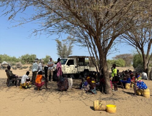
At the end of this frozen geological violence is a quiet watering hole where Turkana herdsmen bring their stock after a long hike across the barren expanse. As Dr. Feibel described the lengths (and depths) desert herdsmen go to find water for their animals, a goatherd and his animals moved in on the water. As if to illustrate Dr. Feibel’s point, the goatherd excavated a hole in the sand to allow the water hidden in the earth to bubble up for the thirsty goats.

The goatherd just climbed out of a well he excavated a few feet into the sand. He's now pouring out the water into a portable plastic trough for his waiting animals.

The Lothagam watering hole is a key resource for all the pastoralist Turkana in the area. When multiple flocks get to the area, they loop the lush oasis like aircraft in a holding pattern, waiting to swoop in to refuel.

A goatherd and his animals getting ready to move in on the Lothagam watering hole.

The watering hole is surrounded by palm trees and ignimbrite boulders, a perfect place to take a breather before starting a return hike with no guide but a GPS, compass, and memory. Fortunately everyone knew how to use all three.

Some groups were tracked by a curious group of donkeys, a rare sight closer to TBI. These animals are never far from water and when they can't find any, they'll start to dig their own well. A handy talent.
As I took the hint and took a few swigs of my own water, Dr. Feibel did a water check. Everyone was equipped with at least half a liter. “Alright, you have what you need. Get back to camp!” And with that, the walk was dismissed and the field school began a wandering hike across the desert without escort. Fortunately, everyone knew how to use their GPS and compasses and arrived safely back at camp for a lentil lunch washed down with a few liters of water.

Dr. Craig Feibel sends the students forth across the desert.

A stalwart acacia offering one of the few non-rocky slices of shade in Lothagam. There are so few trees in the area that they each were given a name in the early '90s when Dr. Feibel and Dr. Leakey excavated Lothagam in earnest. Unfortunately, I wasn't formally introduced to this one.
Along the way, caves were explored and fossils discovered. Par for the course at Lothagam.

Rob hefts a fragment of hippo palate. We're looking at the upper teeth from a food-eye-view. The snout would have been to the left and the rest of the body to the right.

Rob hefts a piece of elephant limb bone. There were multiple species of proboscidean (the family that elephants belong to) wandering the winding rivers of Lothagam 6 million years ago and their remains could be mistaken at first glance for tree trunks.

The three caballeros tracked us nearly to the truck. They didn't offer to give us a lift.
As we loaded back up into the truck for the trip back to TBI, Natalie spoke for us all, “I wish we could have another night out here. Or maybe two more. This place is awesome.”

Nearly back to the truck and a final farewell to the sloping red rocks of Lothagam.

There are still fossils in these hills waiting to be found...