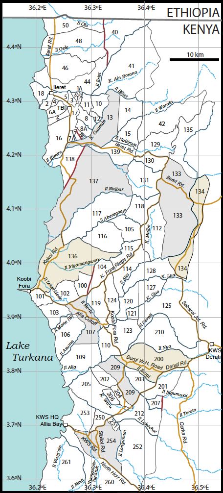
Figure 1. An index map showing numbered areas of the Koobi Fora region. Areas that are bisected by a road or roads are shaded to emphasize their extent. Where Faults have been used as boundaries are shown as a thick red line. Roads have been named to ease verbal description of the areas. Only principal roads are shown. Kolom (Dasanetch for a small stream) is abbreviated “K.” in stream names.
Synoptic description of Areas (grouped below into those in the Ileret, Koobi Fora, and Allia Bay regions)
Ileret Region
Area 1 is bounded on the south by the limit of exposure of Pliocene and Pleistocene strata, on the west along a line through an area covered by alluvium, on the north by Il Eriet, and on the east by the bed on a small tributary to Il Eriet.
Strata belong to the upper part of the KBS Member, the Okote Member, and the Chari Member, ranging in age from ~1.7 to ~1.4 Ma
Area 1A This small triangular area is bounded on the east by a band of alluvium, as it is on the west. The northern boundary is Il Eriet.
Strata belong to the upper part of the KBS Member and the Okote Member, ranging in age from ~1.7 to ~1.45 Ma.
Area 2 includes the town of Ileret, is bounded on the northwest by Il Eriet, on the east manly by Ileret Road, on the southwest by an 4 arbitrary line segments through areas with little or no exposure, and by Lake Turkana on the west.
Strata belong to the Okote Member and Chari Member, ranging in age from ~1.5 to 0.7 Ma
Area 3 is bounded on the south by the limit of exposure of Pliocene and Pleistocene strata, on the west by a line through an area with no exposure of Pliocene or Pleistocene strata, on the north by Il Eriet, and on the east through an area with no exposure of Pliocene or Pleistocene strata and then along the bed of a tributary to Il Eriet.
Strata belong to the Okote Member and Chari Member, ranging in age from ~1.45 to somewhat less than 0.75 Ma (Silbo Tuff).
Area 4 bounds Area 2 to the northwest along an line through areas of little exposure, and ends at the limit of exposure of Pleistocene strata to the northeast on Ileret Ridge. The southeastern boundary is made by five arbitrary segments through areas with little exposure of Pliocene or Pleistocene strata.
Strata belong to the Okote Member and Chari Member, ranging in age from ~1.45 to somewhat less than 0.75 Ma.
Area 5 is bounded on the southwest by the Ileret road, and by the edge of outcrop of Pleistocene strata, on the north by Il Eriet, and on the east by a line through an area with no exposure of Pliocene or Pleistocene strata.
Strata belong to the Chari Member, ranging in age from ~ 1 Ma to somewhat less than 0.7 Ma.
Area 6 is the southernmost of the productive fossil collection areas along the western side of Ileret Ridge. Its southern boundary is within an area of bushland south of the principal exposures in the area, its western boundary is Lake Turkana, and its northern boundary is placed through an area of limited exposure. The eastern boundary is the limit of exposure of Pliocene and Pleistocene strata.
Strata belong to the upper KBS, Okote, and Chari Members, ranging in age from ~1.7 to 1.3 Ma.
Area 6A has a southern boundary through an area of limited exposure, its western boundary is Lake Turkana, and its northern boundary is an arbitrary line separating it from Area 2 in the west and Area 4 in the east along which there is little exposure of Pliocene or Pleistocene strata. The eastern boundary is the limit of exposure of Pliocene and Pleistocene strata.
Strata belong to the Okote Member and Chari Member, ranging in age from ~1.5 to 1.3 Ma.
Area 7 is bounded by an unnamed tributary to Kolom Guomde on the west, by the limit of exposure of Pliocene and Pleistocene strata on the north, by a fault and the course of an ephemeral stream on the east, and by Kolom Guomde on the south.
Strata belong to the Chari Member, ranging in age from ~0.8 to < 0.75 Ma.
Area 7A is bounded by the Ileret Road on the west, by the limit of exposure of Pliocene and Pleistocene strata on the north, by an unnamed tributary to Kolom Guomde on the east, and by Kolom Guomde and the Ileret Road on the south.
Strata belong to the Okote Member and Chari Member, ranging in age from ~1.55 to 1.3 Ma.
Area 8B is bounded by a fault and the course of an ephemeral stream on the west, by the limit of exposure of Pliocene and Pleistocene strata on the north, by a line through an area of alluvium on its northeast, and by Kolom Guomde on the south.
Strata belong to the Okote Member, with a probable age range of 1.55 to 1.45 Ma.
Area 8A is bounded on the southwest by a line through an area of alluvium, on the west by the limit of exposure of Pliocene and Pleistocene strata, and on the northeast by a complicated line drawn through an area of exposure of Pliocene and Pleistocene strata that extends through an area covered by alluvium and then into the bed of a tributary to Kolom Guomde. The southeastern boundary is Kolom Guomde.
Strata belong to the KBS Member and the Okote Member, 1.87 to 1.38 Ma.
Area 8 is bounded on the southwest by a complicated line drawn through an area of exposure of Pliocene and Pleistocene strata that extends through an area covered by alluvium and then into the bed of a tributary to Kolom Guomde. On the west it ends at the edge of exposure of Pliocene and Pleistocene strata, and its northeastern boundary is a line drawn through areas with little or no exposure of Pliocene or Pleistocene strata and, in the eastern part, along the bed of a tributary to Kolom Guomde. The southeastern boundary is Kolom Guomde.
Strata belong to the KBS Member and the Okote Member, 1.87 to 1.38 Ma.
Area 9. This slender area is bounded on the south by the limit of exposure of Pliocene and Pleistocene strata, on the west along the bed of an small tributary to Il Eriet, on the north by Il Eriet, and on the east by the bed of a tributary to Il Eriet for the northern part, and in the southern part by a line through an area covered by alluvium.
Strata exposed in this area belong to the upper KBS and Okote Members, ~1.7 to 1.4 Ma.
Area 10 is bounded by a line through an area with little exposure of Pliocene or Pleistocene strata on the southwest, on the west by a line through alluvial cover and then along a tributary to Il Eriet. The northern boundary is marked by the bed of Kolom Ain Borana (a tributary to the Il Eriet), and the eastern boundary is placed along the bed of a tributary to Kolom Ain Borana, and then along the main course of the Kolom Guomde.
Strata belong to the upper Burgi Member, the KBS Member, and perhaps the lower part of the Okote Member, ranging in age from ~2 Ma to ~1.55 Ma.
Area 11. The southwestern boundary of this Area is through a region with alluvial cover; the western boundary likewise runs through an area with alluvial cover to the bed of Kolom Murriech which constitutes the northern half of the western boundary. The northern boundary is Il Eriet, and the eastern boundary follows a tributary of Il Eriet, and then runs through an area covered by alluvium to the drainage divide between Il Eriet and Kolom Guomde.
Strata belong to the KBS Member and the Okote Member, ranging in age from ~1.8 Ma to ~1.5 Ma.
Area 12 has as its southwestern boundary a line drawn through areas with little or no exposure of Pliocene or Pleistocene strata and, in the eastern part, along the bed of a tributary to Kolom Guomde. Likewise, its western boundary is drawn through an area with little to no exposure of Pliocene or Pleistocene strata. The southeastern boundary is Kolom Guomde.
Strata belong to the upper Burgi Member, and the KBS Member, with a probable age range from 1.9 to 1.6 Ma.
Area 13 is bounded by Il Warata and Il Kimire on the south, Kolom Guomde on the west and northwest, and by Kolom Ain Borana and Il Biliet on the north to an arbitrary straight line separating it from Area 14 to the east.
Strata belong to the Lonyumun Member, a combined Moiti-Lokochot member, the Tulu Bor Member, upper Burgi Member and the KBS Member. Strata below the disconformity are 4.2 to 3.4 Ma old; those above the disconformity probably lie in the range 2.0 to 1.8 Ma.
Area 14 is bounded by Il Warata on the south, an arbitrary straight line on the west extending from Il Warata to Kolom Biliet, the course of Il Biliet to a point (4.3ºN, 36.396E), thence southward to the course of Il Warata at 4.271ºN, 36.396ºE.
Strata belong to the Lonyumun Member, ranging in age from ~ 4.3 to 4.0 Ma.
Area 15 is bounded by Il Naitirwa on the south, Il Warata on the north, and the limit of Pliocene strata on the east
Strata belong to the Lonyumun Member, ranging in age from ~ 4.3 to 4.0 Ma.
Area 16 is bounded by Il Kimire on the southeast, by Lake Turkana on the west, by the southern limit of prominent outcrops to the northwest, by the Ileret road and the lower course of Kolom Guomde on the east.
Exposures are poor. Known strata belong to the upper part of the KBS Member and the Okote Member, thus with an age range of ~1.7 to 1.45 Ma. There is a minor exposure in this area that is made up of flat–lying basaltic gravels and mudstones ~3 m thick. The mudstones contain a tuff that does correspond compositionally to known tuffs in the Koobi Fora Formation or in the Galana Boi Formation, and may be between 10 ka and ~650 ka in age.
Area 17 encompasses the area in which Pliocene and Pleistocene strata are not exposed along Ileret Ridge. Its boundaries are thus placed along the edge of outcrop with areas of exposure east and west of Ileret Ridge except that the Ileret Road forms its boundary with Area 16. TBI is in Area 17.
No Pliocene or Pleistocene strata are known from this area.
Area 18 is defined by two prominent branches of the delta of Il Eriet and the shore of Lake Turkana.
No Pliocene or Pleistocene strata are known from this area.
Area 40 (redefined here) Here we redefine Area 40 as including only that north and west of Il Eriet that is bounded by the North Gele Fault on the west, the Ethiopian border on the north, and Il Eriet on the east.
Strata belong to the Lonyumun, Moiti, Lokochot, Tulu Bor, and upper Burgi Members, thus ranging from 4.3 to 2.0 Ma, however there are at least two disconformities in the section.
Area 41 is bounded by Il Eriet on the west, by the limit of Pliocene and Pleistocene strata on the east, and by Kolom Biliet and Kolom Ain Borana on the south.
Strata belong to the Lonyumun Member, the Moiti Member, the Lokochot Member, the Upper Burgi Member, and the KBS Member. The age range is thus from 4.3 Ma to ~1.75 Ma, with a hiatus from at least 2 to 2.5 Ma.
Area 42 is bounded by Il Warata on the north to the edge of the Gombe Basalts that cap the Suregei, then follows the drainage divide between Il Warata and Il Naitirwa and along the contact between volcanic rocks and Pliocene and Pleistocene sedimentary rocks. The western boundary is placed at the beginning of exposure of Pliocene and Pleistocene sedimentary strata to the west.
No strata belonging to the Koobi Formation have been recorded from this area.
Area 44 (defined here) Here we define a new area as that bounded by the North Gele Fault and Il Eriet on the east and south, by Lake Turkana on the west, and by the drainage divide between Il Saparei and Il Eriet and then the drainage divide between Il Eriet and Il Gele in the north.
Strata in this area belong to the upper Burgi Member, the KBS Member, the Okote Member, and the Chari Member, ranging in age from ~2 to
Area 46 (defined here) This area is bounded by the drainage divide of Laga Saparei on the north, east, and south, and by Lake Turkana on the west.
Strata probably belong to the Okote Member and Chari Member.
Area 48 (defined here) This area is bounded by the drainage divide between Il Gele and Il Eriet and Laga Saparei on the south, by Lake Turkana on the west, the drainage divide between Il Gele and Il Olo in the north, and the North Gele Fault in the east.
Strata in this area belong to the upper Burgi Member, and the KBS Member insofar as is known.
Area 50 (defined here) ) This area is bounded by the drainage divide with Il Gele on the south, by Lake Turkana on the west, the border with Ethiopia in the north, and the North Gele Fault on the east.
Strata belong to the upper Burgi Member, and the KBS Member insofar as is known.
Koobi Fora Region
Area 100 lies on the north side of Koobi Fora Ridge east of Area 102. Its southern boundary is the Koobi Fora Ridge Road; its western boundary is principally along the bed of an unnamed minor stream. Its eastern boundary (with Area 104) is along a prominent fault, and its northern boundary is the contact of Pleistocene strata with later alluvium.
Strata in this area belong to the upper Burgi Member, ranging in age from ~2 to ~1.9 Ma.
Area 101. This area lies nearest the Koobi Fora Research station, is bounded on the north and east by the Koobi Fora Road, on the south mainly by a drainage divide, and on the west by the shore of Lake Turkana.
Strata belong to the upper part of the KBS Member and the lower and middle parts of the Okote Member, ranging in age from ~1.75 Ma to 1.45 Ma.
Area 102 is bounded by the Koobi Fora Ridge road on the south and west, by the limit of contiguous exposures on the north, and principally by the bed of an unnamed minor stream on the east.
Most strata belong to the upper Burgi Member and the lower part of the KBS Member. Low exposures in the north of the area are believed to belong to the lower Burgi Member below a disconformity. Strata above the disconformity range in age from ~2 Ma to ~1.7 Ma.
Area 103 is bounded by Lake Turkana on the west, by a drainage divide between it and Area 101 on the north along with the Koobi Fora Ridge Road. Its eastern boundary is at the end of prominent exposure, and the southern boundary with Area 106 is along the bed of Il Morte (W), a prominent ephemeral stream.
Strata in the area belong to the upper part of the KBS Member and the Okote Member, ranging in age from ~1.8 to 1.4 Ma.
Area 104 is bounded on the south by the Koobi Fora Ridge Road, on the west by a prominent fault that separates it from Area 100, on the north by the course of Il Iriyamang’werr, and on the east by the old road (no longer in use) from points south to Ileret.
Strata in Area 104 belong the upper Burgi Member, the KBS Member, and the lower part of the Okote Member, ranging in age from ~2 to 1.5 Ma.
Area 105 is bounded on the east by the Koobi Fora Ridge road, on the northeast and north by Il Aberegaiye, on the west by tributaries to Il Aberegaiye and Il Iriamang’werr, and on the south by Il Iriamang’werr.
Strata belong to belong the upper Burgi Member, the KBS Member, and the lower part of the Okote Member, ranging in age from ~2 to 1.5 Ma.
Area 106 extends on the northeast to the edge of prominent exposure, on the south to Kolom Asuma, on the west to Lake Turkana, and on the north to Il Morte (W) an ephemeral stream that separates it from Area 103.
Strata in this area belong to the KBS Member, ranging in age from ~1.9 to ~1.6 Ma.
Area 107 is bounded on the south by an east-west line, on the west by Kolom Asuma and then by the edge of exposures in Areas 106 and 103. Its northern boundary is the Koobi Fora Ridge Road, and its eastern boundary is Il Morte, an ephemeral stream that separates it from Area 119. Note, however, that two streams are locally named Il Morte. It is bisected by the Alia Cutoff.
Strata in this area belong mainly to the KBS Member (1.87 to 1.55 Ma).
Area 109. Il Alia (Laga Bura Hasuma on some early maps) forms the southern and eastern boundaries of this area, the shore of Lake Turkana bounds it on the west, Kolom Asa bounds it on the northwest, and it is arbitrarily bounded by an east-west line on the north that separates it from Area 107. Three different features were named Bura Hasuma—an isolated hill in area 110, the principal ephemeral stream draining the central part of the Koobi Fora region (now called Il Alia), and a low swampy area southeast of Bura Hasuma Hill, where several ephemeral streams meet. More recently this low swampy area is referred to as Laga Daudi by the local people.
Strata in the area extend from very slightly below the KBS Tuff to slightly above the Orange Tuff, having an age range from ~1.9 to ~1.55 Ma.
Area 110 includes Bura Hasuma Hill. It is bounded by Il Derati on the south, by Il Alia on the west, and by the Koobi Fora Road on the east.
Strata belong to the upper Burgi and KBS Members, with an age range from ~2.0 to 1.8 Ma.
Area 112 extends from the Koobi Fora Ridge Road on the northwest to the edge of exposures along Kolom Malbe in the northeast, where the boundary is an arbitrary line placed through a large area of surficial deposits. The eastern boundary is along the divide between two branches of small tributary to Il Alia east of Kolom Malbe which join before reaching Il Alia. The southern boundary is the course of Il Alia, and the southwestern boundary follows a small unnamed tributary to Il Alia west of Kolom Malbe back to the Koobi Fora Ridge Road. In some early publications, this area is referred to as Area 105E (E for east).
Strata in this area, though poorly exposed, belong to the KBS Member, the Okote Member, and the lower part of the Chari Member, thus ranging in age from 1.86 to ~1.3 Ma.
Area 114 extends from its boundary with Area 112 on the east to Il Alia on the south, to an unnamed northern tributary to Il Alia on the west, and through surficial deposits in an arbitrary line to the Koobi Fora Ridge road which forms the northern boundary.
Exposures are poor in this area, and it has been little investigated. Strata are believed to belong mainly to the KBS Member, but may include some strata of the upper Burgi Member.
Area 115 has its southeastern boundary at the Koobi Fora ridge Road, its western boundary along the old road (no longer in use) leading from points south to Ileret, and its northern boundary along Il Iriyamang’werr.
A small, but important outcrop of the upper part of the lower Burgi Member is exposed in the bottom of the channel of Il Iriyamang’werr, but the bulk of the strata belong to the upper Burgi Member and the KBS Member, ranging in age from ~2 to 1.7 Ma.
Area 116 is bounded on the north by Il Aberegaiye, on its northeast and east by a southern tributary to Il Aberegaiye and a northern tributary to Il Iriyamang’werr and the course of the latter stream. The southern boundary is place across a broad area of alluvium to the old Ileret road (no longer in use, and barely visible in this region) back to Il Aberegaiye.
Strata in this area belong to the upper part of the Tulu Bor Member, the lower part of the lower Burgi Member, and, above a disconformity, to the upper Burgi Member. The upper part of the Tulu Bor Member is exposed in the southern part of the area along Kolom Ninikaa. Strata below the disconformity have a probable age of 3.3 to 3.0 Ma; those above, a probable age of 2.0 to 1.9 Ma.
Area 117 is bounded on the south by Il Aberegaiye, on the west by the Kokoi Road, on the north by Il Naibar, and on the east along a line drawn through a region covered by alluvium.
Strata belong principally to the Lonyumun, Lokochot, and Tulu Bor Members, but the easternmost part of the area contains strata of the upper Burgi Member and the upper part of the KBS Member. Most fossils derive from above the Tulu Bor Tuff, and have a probable age range of 3.4 to ~2.9 Ma.
Area 118 is bounded on the southeast and east by the Koobi Fora Ridge Road, on the southwest by Il Aberegaiye, on the west by the edge of prominent outcrop (where it adjoins Area 117), and on the north by Il Naibar.
Strata belong to the upper Burgi Member, the KBS Member, and the lower part of the Okote Member, thus ranging in age from ~ 2 Ma to ~ 1.5 Ma.
Area 119 is bounded on the east by the Koobi Fora Road, on the south by Il Alia, on the west by Kolom Morte, and on the north by the Koobi Fora Ridge Road.
Strata belong to the upper KBS Member and the lower part of the Okote Member, with a probable age range of 1.7 to 1.45 Ma.
Area 120 is bounded by Il Alia on the west and along part of its northern extent. The boundary eastward follows Kolom Lua to a north-south line that extends to Kolom Guo in the south, and then follows Kolom Guo almost to its southern boundary, which lies along a small drainage that marks the northern limit of exposures of Area 123.
Strata belong to the KBS Member (1.87-1.65 Ma).
Area 121. This small, nearly square, area is bounded by Kolom Guo on the west and north, by an arbitrary N-S line on the east, and by an unnamed ephemeral stream on the south.
Strata belong to the KBS Member, ranging in age from ~1.9 to 1.65 Ma.
Area 123. This area is bounded on the south by Il Derati, on the west by the Koobi Fora Road, on the north by Il Alia and Kolom Guo, and by a NNW arbitrary line on the east.
Strata belong principally to the upper Burgi and KBS Members, with the Lower Ileret Tuff being the youngest unit known. Most fossils derive from strata ~1.9 to 1.6 Ma in age.
Area 124 is bounded by the Koobi Fora Road on the west, the Koobi Fora Ridge Road on the north, and from there southward through surficial deposits to a northern tributary to Il Alia and along Il Alia. From 3.885 N, 36.334 E, the boundary follows a small streambed northward to the edge of outcrop, and then connects back to the Koobi Fora Road.
Strata belong to the KBS Member (1.87-1.65 Ma).
Area 125 is bounded by Il Derati on the south, by an arbitrary line on the west, by Kolom Guo and a northern tributary of Kolom Guo for much of the northwest, by Kolom Lua on the north, and by the Derati-Ileret Road on the east.
Miocene rhyolites are exposed in the eastern part of this area; Pliocene strata belong to the upper Burgi Member, and the KBS Member, and the highest levels may approximate the top of the KBS Member.
Area 127. Much of the southern border of this area is the course of Kolom Guo, and the western boundary is the arbitrary north-south line that separates it from Area 120; the northern boundary is Kolom Lua, and the eastern boundary extends across a small area of surficial deposits to a small northern tributary of Kolom Guo.
Strata belong to the upper Burgi Member and the KBS Member, with the Malbe Tuff being near the highest level, giving a probable age range of ~2.0 to ~1.84 Ma.
Area 128 is bounded on the south by Kolom Lua, on the west and north by Il Alia, and on the east by an arbitrary border trending SSE from Il Alia to the Sabarei Junction Road and thence to Kolom Lua.
Strata belong to the KBS Member, the Okote Member, and the Chari Member, ranging in age from ~1.87 to ~ 0.75 Ma.
Area 129 includes Pliocene strata exposed along Il Naitirwa. We have modified the eastern and northern boundaries slightly to include the northern Naitirwa drainage. The southern boundary of the area follows the Ileret Road, it western boundary is placed through an area covered by alluvium, and its northern boundary is placed within volcanic rocks to ensure inclusion of all Pliocene strata; its eastern boundary is the drainage divide between Il Naitirwa and Kolom Masich.
Strata belong to the Lonyumun Member, possibly the Moiti and Lokochot Members, the Tulu Bor Member, the upper Burgi Member, the KBS Member, and the lower part of the Okote Member. The age range is thus ~4.3 to 1.5 Ma.
Area 130 is bounded on the north and east by the Ileret Road, on the south by Il Kimire, and on the west by an arbitrary line drawn through an area of alluvial cover.
Strata belong to the Tulu Bor Member, and lower Burgi Member, the upper Burgi Member, the KBS Member, and the Okote Member.
Area 131 is bounded on the north by Il Kimire, on the east by the Ileret Road and the Koobi Fora Ridge Road, on the south by Il Naibar, and on the west by the edge of prominent exposures.
Strata belong to the upper Burgi Member, the KBS Member, the Okote Member, and the lower part of the Chari Member, thus ranging from ~2.0 to ~1.3 Ma.
Area 133 is bounded by the Ileret Road on the north, by the course of Il Alia on the east, and northward from Il Alia by an unnamed tributary to an alluvial plain back to the Koobi Fora Ridge road that marks the end of the area at the northern part of its western extent.
Strata belong to the Lonyumun Member, the Moiti Member, the Lokochot Member, the Tulu Bor Member, and, above an erosion surface, the KBS Member and Okote Member, thus ranging in age from ~4.3 to 1.4 Ma.
The Bench Tuff, exposed at archeological site FxJj63, was defined at Konso, Ethiopia, where it lies below the Bright White Tuff that is correlated with the Chari Tuff of the Koobi Fora Formation, hence it lies in the uppermost part of the Okote Member, so at least some parts of the Okote Member are represented.
Area 134 is a slim area at the eastern basin margin bisected by the Sabarei Junction Road and the eastern end of the Ileret road. Its western and northern margin are marked by Il Alia; its eastern margin by the limit of Pliocene or Pleistocene sedimentary outcrop, and its southern margin by the Sabarei Junction Road.
Strata belong to the Moiti Member, the Lokochot Member, the upper Burgi Member, the KBS Member, the Okote Member, and the Chari Member. The age range is thus 4.3 to
Area 135 includes exposures along Kolom Masich. The southern boundary is placed along a minor road across an alluvial surface, and then at the drainage divide between Kolom Masich and other ephemeral drainages to the south. The western boundary is the divide between Il Naitirwa and Kolom Masich. The northwestern boundary is placed along the drainage divide between Il Warata and Kolom Masich or Chen Alia.
No Pliocene or Pleistocene strata have been recorded in this area.
Area 136 is an area in which exposures are very low. It is bounded by Lake Turkana on the west, by an line extending from the lakeshore to the lower reaches of Il Naibar, then southward along the Kokoi Road to Aberegaiye, then to the northeast along Il Aberegaiye, and along the old Ileret road where it bounds Area 116, across a patch of alluvial cover to Il Iriamang’werr, thence south-southwest to the northwestern tip of Area 104, and back to the lake along the northern borders of Areas 104, 100, 102 and 101. The Kokoi Road runs through its western extent.
Strata in this area belong to the Lonyumun Member, Lokochot Member, the Tulu Bor Member, the lower Burgi Member, and the base of the upper Burgi Member, with a corresponding age range of 4.3 to ~2.0 Ma.
Area 137 is a large area encompassing the Kokoi volcanic highland. It is bounded by a fault along the northwestern margin of the Kokoi, by Il Kimire in the northeast, along the western edge of Pliocene and Pleistocene strata in the East, and along Il Naibar in the south.
Strata belong to the Lonyumun Member, Lokochot Member, and Tulu Bor Members, ranging in age from ~4.3 to 2.9 Ma.
Area 138. This large, low-lying area northwest of the Kokoi is bounded by Lake Turkana on the west, by the course of Il Kimire in the north, and by the fault along the Kokoi on the southeast.
Strata belong Lonyumun Member, Lokochot Member, Tulu Bor Member, and above a disconformity, to the Chari Member. The older strata range in age from ~4.3 to ~3.1 Ma.
Area 139 lies northeast of the Kokoi and is bisected by the Ileret Road. Its northern boundary is formed by Il Warata and Il Naitirwa; its eastern boundary is placed through an area of alluvial cover up to Il Kimire, which forms its southern border.
Strata in this area belong to the Lonyumun Member, the Lokochot Member, the Tulu Bor Member, and possibly the lower Burgi Member. Most strata range in age from ~4.3 to ~3.1 Ma. The lower Burgi Member has an age range from 2.64 ± 04 Ma (the age of the Burgi tuff to a little less than 2.53 ± 0.03 Ma (the age of the Lokalalei Tuff).
Allia Bay Region
Area 200 is bounded by the Derati Road on the south and east, by Il Burgi on southwest, and by Il Derati and Il Nya on the north.
The area remains poorly investigated, but includes Lonyumun Member strata resting on Miocene ash flows, the Moiti Tuff and the lower part of the Moiti Member, and above a disconformity, strata tentatively identified as the upper part of the KBS Member, and the lower part of the Okote Member. The Lower Lokalalei and Burgi Tuffs have been identified at several places in the western part of this area. In sum, strata range from ~4.4 to ~1.5 Ma.
Fossils from the area most likely lie in one of three time intervals: 4.4–3.9 Ma or 2.7–2.5 Ma, or 1.9–1.4 Ma.
Area 201 is bounded by Il Ingumwai on the south and southwest, by the Derati Road on the northwest, and mainly by the old “Fora Water Hole” road on the east.
Kubi Algi, made of Miocene ash flows (~13 Ma), lies within this area; exposures of strata that might be assigned to the Koobi Fora formation are very limited.
Area 202 is bounded on the southeast by an ephemeral stream (unnamed) that separates it from Area 204, on the west by the limit of outcrop of the Koobi Fora Formation, and on the east by the old road (now unused) that led to Hasuma forest. The northern boundary is the channel of Il Alia.
Strata in this area include the Tulu Bor Member above the Hasuma Tuff to slightly above the Burgi Tuff, thus ranging in age from ~2.8 to ~2.6 Ma. Williamson’s molluscan “Suregei Isolate” is best expressed in this area.
Area 203. This triangular area is bounded by the Derati Road on the south, by Il Ingumwai on the west, and by Il Burgi on the northeast.
Strata in this area have proven quite difficult to place stratigraphically. It is reasonably certain that all strata in the area lie below the Burgi Tuff (2.64 Ma), but a lower boundary is more difficult to establish.
Area 204 is bounded by the limit of exposures of the Koobi Fora Fm. on the south, by an unnamed ephemeral streams of medium size on the west and north, and by the drainage divide between Il Ingumwai and streams that drain to the west, the northern 2/3 of which coincide with the Koobi Fora Road.
Strata in the area belong to the Lokochot, and Tulu Bor Members of the Koobi Fora Formation. The Lokochot Tuff is the oldest known unit is the area, and the Hasuma Tuff is the highest. This is the only area in which there is a nearly complete section between the Tulu Bor Tuff and the Hasuma Tuff. Most strata lie above the Tulu Bor Tuff, so most fossils from the area are in the age range from ~3.4 to ~2.8 Ma in age.
Area 205: Like Area 253, Area 205 is very low lying, is bounded by Il Lokochot and an unnamed channel that extends to Lake Turkana on the southwest, by the lower course of Il Alia on the north, and by the beginning of outcrops of Koobi Fora Formation, on the northeast. The southeastern border is the Sibiloi Park Road.
It is probable that minor areas of outcrop in this area belong to the Moiti and Lokochot or Tulu Bor Members.
Area 206 is bounded on the east by Area 204, and on the south, west and north by Area 205.
Strata in this area belong to the Lokochot Member and to the lower part of the Tulu Bor Member of the Koobi Fora Formation, ranging in age from ~3.5 Ma to ~3.1 Ma.
Area 207 is bounded by Il Toroto on the south and west, by Il Ingumwai on the north, and by a fault along much of the eastern limit.
Strata in this area belong to the Tulu Bor and lower Burgi members of the Koobi Fora Formation, ranging in age from the Tulu Bor Tuff to the Lokalalei Tuff, thus spanning 3.4 to 2.55 Ma.
Area 209 is bounded by the Derati Road on the south, by the drainage divide between Il Ingumwai and westward draining streams on the west, by a low seasonally inundated area on the north, and by Il Ingumwai on the east. It is bisected by the Koobi Fora Road
Very minor exposures of Pliocene rocks are present in this area along the western side of Il Ingumwai, most likely belonging to the upper part of the Tulu Bor Member.
Area 210. The original extent of this area was retained, but east of ~36.48ºE no strata of the Koobi Fora Formation are known. The southern boundary is Il Nya, the northern boundary is Il Derati, and the eastern boundary is the Derati Road.
There has been little investigation of this area. The Lokochot Tuff (3.56 Ma) and Toroto Tuffs (3.32 Ma) have been identified in the western part of the area, it is probable that these are disconformably overlain by strata of the upper Burgi Member, but the age of the youngest strata is not known.
Area 212 is bounded by Il Lokochot on the south, by the Derati Road on the northwest, by Il Ingumwai and Il Toroto on the northeast, and by the limit of sedimentary strata on the east.
Strata in this area belong to the Lonyumun, Moiti, Lokochot, and Tulu Bor Members of the Koobi Fora Formation, becoming progressive younger to the north, such that the Lonyumun Member is confined to exposures along Il Lokochot, and deposits of the Lokochot and Tulu Bor Members are exposed in tributaries to Il Ingumwai. The Toroto Tuff (3.33 Ma) is relatively widely exposed. The age range is from ~4.1 Ma to 3.1 Ma.
Area 250. Roughly triangular in shape, this area is bounded by the Park Road on the southeast, by Il Lokochot on the north, and by the limit of Pliocene outcrop along the west.
Strata belong to the Moiti and Lokochot Members of the Koobi Fora Formation, but the Tulu Bor Tuff is also present in the western part of the exposures. The age range is thus ~4 to 3.4 Ma.
Area 251, a small area, is bounded by Area 252 on the south, by the Park Road on the northwest, by Il Lokochot on the northwest, and by Il Lonyumun on the east.
Strata in this area belong to the Lonyumun Moiti and Lokochot Members of the Koobi Fora Formation, thus ranging in age from ~4.4 to ~3.5 Ma.
Area 252. The southwest border of this area is the Allia Bay-North Horr Road. The western boundary is formed by Il Lonyumun and a tributary to it. The northern boundary is formed by the main channel of Il Lokochot, and the eastern boundary is arbitrarily placed to include Pliocene sedimentary strata along a boundary that trends NNE.
Strata within this area belong to the Lonyumun Member, with a small extent of strata in the Lokochot Member. Most strata lie below the Moiti Tuff (3.97 Ma), but strata up to 3.6 Ma (the Lokochot Tuff) are also present. “Snail Hill”, which preserves a shellbed intruded by Gombe Basalt Dikes, lies within this area. Garma Tochu, a high area in the southern part of this area may be an eruptive center of the Gombe Basalts.
Area 253. This low lying area is bounded on the south by the Park Road, on the east by Area 250, and on the north by Il Lokochot and an unnamed channel that extends to Lake Turkana. The western boundary is the shore of Lake Turkana.
Pliocene outcrops in this area, if any, are of minor extent.
Area 254. The southwest border of this area is common with the northeast border of Area 260. The northern border is placed at the road from the KWS Headquarters at Allia Bay to the interior of Sibiloi National Park as far east as 36.3307E longitude where the boundary with Area 251extends to the southeast north of Sibilot Mountain, and then curves to the northeast until it reaches Il Lonyumun. The eastern border is formed by the principal north-south trending channel of Il Lonyumun, and then by a tributary to Il Lonyumun that reaches the Allia Bay-North Horr Road.
Miocene ash flow tuffs ~13.1 Ma old and basalts are exposed on Sibilot Mt. (the site of the “Petrified Forest”). Pliocene strata are principally of the Lonyumun Member of the Koobi Fora Formation below the Moiti Tuff. Thus the age range is ~4.4 to 4.0 Ma.
Area 260 is the southeastern-most of the paleontological collection areas. Like Area 261, it is arbitrarily bounded at latitude 3.5158ºN on the south, by the Allia Bay-North Horr road from the southeasternmost point to the Karsa Gate Junction with the old road to KWS Headquarters at Allia Bay, and then follows the old road to the KWS Headquarters which itself follows the drainage divide between Il Moiti and Nyongololong’atuk west of the Nyongololong’atuk crossing. The northwest border is formed by the shore of Lake Turkana.
As with Area 260, strata range from the Lonyumun Member to slightly above the Tulu Bor Tuff at the base of the Tulu Bor Member, an age range of ~4.4 to 3.4 Ma.
Area 261 is the southwestern-most of the paleontological collection areas. It is bounded (arbitrarily) at latitude 3.5158ºN on the south, by the shore of Lake Turkana on the west and north, and by Il Moiti on the east where it adjoins Area 260.
Strata range from the Lonyumun Member to slightly above the Tulu Bor Tuff at the base of the Tulu Bor Member, an age range of ~4.4 to 3.4 Ma. Much of the highland of Jarigole in this area is covered by Gombe Basalts (~4 Ma old), some of which are intrusive into Lonyumun Mb. strata on the west flank of Jarigole.